 |
 |
 |
|
 |
OFFICE OF THE CHIEF EXECUTIVE OFFICER: BARPETA ZILLA PARISHAD: BARPETA. PANCHAYAT & RURAL DEVELOPMENT DEPARTMENT: GOVT. OF ASSAM |
||||
|
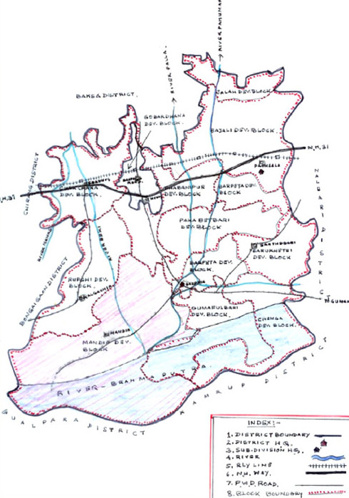
District Profile at a Glance 1. Geographical Location - Barpeta district with its headquarter at Barpeta town was created and started functioning from 1st July'1983. The district is spread within 26°45' to 26°49' North latitude and 90°45' to 90°15' East latitude with a total geographical area of 324500 Ha. The District is surrounded by the Bhutan Hills and Bagsa District in the North, Nalbari District in the East, Kamrup and Goalpara district in the South and Bongaigaon and Chirang District in the west.2. Administrative set up - The Administrative set up of the district is mentioned below. 3. Demography - As per 2001 Census the present population of the district is 16,42,420 out of which male is 8,46,106 and female is 7,96,314. The sex ratio is 941 per 1000 male. The density of population is 506 per sq-KM. As per 2001 census the scheduled caste and scheduled tribes population of the district is 93861 and 123266 respectively consisting 5.71% and 7.5% of the total population of the district respectively. 4. Physical feature -The Barpeta District is situated at the plains of Brahmaputra valley and northern part of the District is covered by hilly area. In the Southern and Western side of the district, Char areas are created by Brahmaputra and by Beki rivers, which comprises a major part of the district. 5. Soil - The soil of Barpeta district may be classified as Sandy, Sandy loam and forest soil. 6. Climate & Rainfall - Barpeta district enjoys tropical monsoon climate having two distinct seasons - Summer and Winter. The Summer season from March to May is followed by the monsoon from June to September. The retreating monsoon occurs from October to November. The winter season from December to February is characterized by average temperatures remaining generally above 12 to 8 degree Celsius. The average annual rainfall ranges from 360 to 400 cm. 7. Flora and Fauna - The District is rich in flora and fauna. Manas National park, a World Heritage Site, with a prominent Tiger project situated at a distance of 52 KM towards north west from Barpeta Town is ornamented with rare and diversified wildlife. There are 543 species of plants, 60 species of mammals, 312 species of birds, 42 species of reptiles, 7 species of amphibian, 54 species of fishes and 100 spices of insects in the park. 8. Literacy - As per 2001 census, total literate persons of the district are 7,69,225. Out of which 4,56,870 are male and 3,12,355 are female. The rate of literacy of male and female are 65.95% and 57.35% respectively. 9. Socio economic condition - The district of Barpeta is one of the leading agriculture district of Assam. Although the total gross copped area in Barpeta District is 3,10,000 hectares, the net cropped area is only 1,76,900 hectares. The cropping intensity is 175% and integrated area is 45192 hectares. The district has 1,86,205 nos. farm families out of which, 19798 nos. are big farm families, 6543 nos. are marginal farm families, 78582 nos. are small farm families and 22394 nos. are landless families. The main crops grown in the district are paddy, wheat, mustard oil, jute, potato, pulses, fruits, vegetables etc. The land distribution for cropping is as stated below.
10. Resource Inventory- Infrastructure- 1) Roads - The main route of PWD roads are as stated below,
2) Railway- Length of Railway in the district is 47 KM and there are 6 nos. of Railway Station in the district viz. Sorbhog, Barpeta road, Guwagacha, Sarupeta, Pathsala and Niz Sariha. 3) Telecommunication-There are 2(two) Sub Divisional level Office of Telecommunication in the District. One at Barpeta town and other at Barpeta Road town. 4) Credit facilities- Credit facilities are taken up through different Bank branches. There are 65 nos. of different nationalized and regional rural bank branches in the District. 5) Educational Institutions- Educational Institutions of the District are as below,
6) Hospital and Health Centres- Details of Hospitals and Health Centers of the District are as below:-
7) NGOs, Self Help Group etc.- A number of NGOs and SHGs in the District are taking active part in the field of Agriculture, Fishery, Health and Education. The Al-Amin Charitable Trust Fund located at Kalgachia is one of the reputed NGO involved in the Educational sector. Barpeta District Fish Seed Producers Association at Dabaliapara is a registered society formed with the objective of production of fish seedling on large-scale basis. This society has taken active part for marketing and transportation of fish seed and edible fish to various fish market like Guwahati, Mangaldoi, Dhekiajuli, North Lakhimpur etc. Besides them, many other reputed NGOs have been taking active part in various other programmes across the district. Cadastral Map of Barpeta District |